乞力马扎罗山最受欢迎的经典线路——玛切姆线,对比同样受欢迎的“可口可乐”线进阶被称作“威士忌线”。由于地貌变化丰富,难易度适中,成为最流行的攀登线路之一。从喧闹的玛山姆小镇出发,经过希拉营地,于巴兰科营地观云海落日,最终登顶,征服乌呼鲁峰!走近非洲传奇,亲历大自然的壮美。顶峰的诱惑也许只是一个上路的理由而已。
请注意,威士忌线有2个版本,8天版本(其中登山天数6天)和9天版本(其中登山天数7天)。从登顶率角度,9天版本明显高于8天版本,因为适应海拔的时间更为充分。除非我们的客户已经有充足的户外经验和高海拔徒步经验,否则请选择9天版本,最大限度增加登顶率。
Day 01: 2020: Arrival +moshi
Arrive at Kilimanjaro international airport meet and great by our representative transfer to moshi for the overnight at Hotel booked on bed and breakfast
Accommodation : AISHI MACHAME HOTEL (or similar)


- Reference Hotel Pictures
Aishi Machame Hotel酒店静静地坐落在乞力马扎罗山(Mt Kilimanjaro)的绿色山麓,是攀登前充电和增强体力的理想场所。酒店的领土是一个郁郁葱葱的美丽花园,树木盛开,鸟儿啁啾。长期以来,许多野生动物将Aishi Machame Hotel作为其永久居住地。在温暖的日子里,您可以去被绿色植物围起来的舒适游泳池,沐浴在非洲的阳光下。


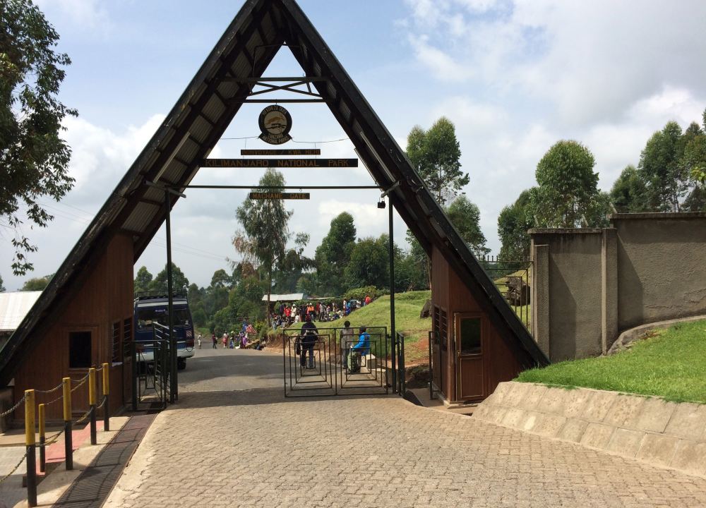
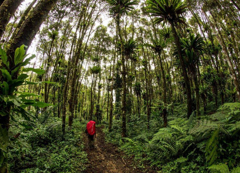
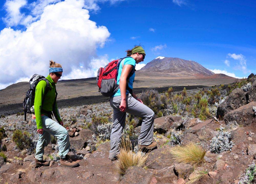
We will pick you up from the entrance of the Arusha hotel and drive you 1 hour to the Machame Gate to register for the climb and prepare for the climb with the other staff (cooks and porters). According to local regulations, each mountaineering team needs to be registered, and the luggage carried by the husband needs to be weighed, which can not exceed 40 kilograms per person. After the rectification, we need to walk through a dense tropical rainforest for 5-6 hours in the deep forest. Along the way, you will pass through coffee fields, which are green grass, trees and ferns, until you reach Machame Camp (3,048m above sea level). The Marsam Line is the perfect combination of difficulty and scenery, and we will cut across the Hilla Mesa in the southwest to the Summit camp in the southeast, with views of the entire southern foothills.
Accommodation : Machame Hut CampTent in Camping site
Meal : Breakfast; Lunch (Picnic); Supper (Camp Meal)
Trekking Distance : 5 kilometers
Trekking Time : 6-7 hours
Altitude Gains & Losses : +1200 meters

After a break from Marsam Camp, cross a beautiful river valley and cross a fast-flowing river. It is very pleasant to be on top of the mountains and in the deep woods. Breathing the fresh air, looking at the fresh green after the rain. The trees of the tropical rain forest are often entangled by various parasitic plants, so the whole forest is entangled with vines, as if it were a fishing net. Perhaps because it was a lazy afternoon, the larger animals were hiding, except for the occasional monkey and squirrel in the distant treetops. Continue along the senecio ridge to the Hilla Alpine Wilderness. Set up tents and dine at Shira Camp (3803m above sea level). Learn to use high pressure tanks and oxygen tanks, so that the body gradually adapt to the high altitude climate environment.
Accommodation : Shira CampTent in Camping site
Meal : Breakfast; Lunch (Picnic); Supper (Camp Meal)
Trekking Distance : 11 kilometers
Trekking Time : 5-6 hours
Altitude Gains & Losses : +755 meters

Start the climb with very few boulders and rocks, then steadily climb up the lava tower and stop for lunch around noon. For those interested, continue climbing the volcanic rocks (4000m above sea level) (a slight headache may occur due to the high altitude). From the volcanic rock we will walk for about 2 hours through a trail with many volcanic rocks to Barranco Camp (3962m). We were lucky enough to see the magnificent Uhuru Peak again and end the day in the sunset.
Accommodation : Barranco CampTent in Camping site
Meal : Breakfast; Lunch (Picnic); Supper (Camp Meal)
Trekking Distance : 11 kilometers
Trekking Time : 5-6 hours
Altitude Gains & Losses : +200/-100 meters


After spending the night at the Barranco Wall, you'll cross this awesome barrier, which is often easier to do than you think. Below the Heim Glacier, you will see the true beauty of Kilimanjaro. We then travel through arid ridges and valleys, crossing the Karanga Valley to connect with the Mweka line. This is the preferred route down from the top, so we have to remember it. Arrive at Barafu camp (4681m). Balaf means "ice" in Swahili. We will spend the night in this deserted camp. We were completely exposed to the omnipresent wind, and the tent carried a narrow ridge below.
Make sure to familiarise yourself with the terrain before it gets dark to avoid any surprises, with the summit still 1214 metres high, where you will take your final challenge. Prepare your gear and pole insulation suit to prepare you for the summit challenge. This should also include your headlights, camera batteries and make sure spare equipment is also available. To prevent the water from freezing, pour it into a thermos. Try to go to bed early to rest and recover.
Accommodation : Barafu campTent in Camping site
Meal : Breakfast; Lunch (Picnic); Supper (Camp Meal)
Trekking Distance : 11 kilometers
Trekking Time : 7-8 hours
Altitude Gains & Losses : +800 meters
Highest Altitude : 4681 meters

You will get up at about 23:20, enjoy some tea and biscuits, and shower overnight. You will head northwest through the Dastera Point forest to the crater rim. For many climbers, the six-hour walk to Stella Point is the most mentally and physically challenging route. At Stella Point (5775m above sea level), stop and rest for the most spectacular sunrise (weather permitting).
The journey from Stella Point to Uhuru Peak (5895m) takes about 2 hours and may be subject to snow and snow, your time to reach the summit will depend on the weather conditions, so enjoy the achievement once you reach the summit. It takes about three hours to walk from the summit back to Camp Baraf. At the Camp you will have a good rest and gather the rest of your gear before heading to Mweka Camp (3090m above sea level).
The route is not very difficult, we will follow the rock and forest path into the swamp, and finally into the forest, the camp is located on the upper level of the forest, and can expect fog or rain later in the afternoon. We'll prepare dinner and a bath for you.
Accommodation : Millenium CampTent in Camping site
Meal : Breakfast; Lunch (Picnic); Supper (Camp Meal)
Trekking Distance : 16 kilometers
Trekking Time : more than 8 hours
Altitude Gains & Losses : +1214/-2805 meters
After breakfast, we hike 4 to 6 hours back to the Mweka Gate (1,641m). It was a day of long descent, and some climbers may have experienced knee discomfort. Knee pads and trekking poles became essential.
At the gate of Vika Hill, you will sign your name on a register. This is also where successful mountaineers get their summit certificates. Climbers who reach Stella Point will receive a green certificate. Climbers who reach Uhuru will win gold MEDALS. From Vika Gate we hike through a muddy 3 km road (1 hour) and arrive in the small town of Vika where we will enjoy a delicious lunch, after which we will drive you back to the moshi Select hotel for a hot bath.
Accommodation : AISHI MACHAME HOTEL (or similar)
Meal : Breakfast; Lunch (Picnic)
Trekking Distance : 12 kilometers
Trekking Time : 5-6 hours
Altitude Gains & Losses : -2200 meters
- Reference Hotel Pictures
Aishi Machame Hotel酒店静静地坐落在乞力马扎罗山(Mt Kilimanjaro)的绿色山麓,是攀登前充电和增强体力的理想场所。酒店的领土是一个郁郁葱葱的美丽花园,树木盛开,鸟儿啁啾。长期以来,许多野生动物将Aishi Machame Hotel作为其永久居住地。在温暖的日子里,您可以去被绿色植物围起来的舒适游泳池,沐浴在非洲的阳光下。
As there are no activities scheduled for this day, you can choose the flight departure of the day according to your own arrangement
According to the flight time, you will have the corresponding free time at your disposal, do not want to lazy in the hotel, just use this day to experience the life of the locals. You can walk in the local, shopping, leisurely and comfortable. Then head to the airport for an international flight back home.
Accommodation : Own arrangement
Meal : Breakfast
Route Type 登山
Route Code40F-KILMAC
Follow our subscription account to stay informed about the latest Pama information and the most unique outdoor travel routes around the world.

For online consultation, route consultation, event customization, and business cooperation, please add Xiaoma WeChat.