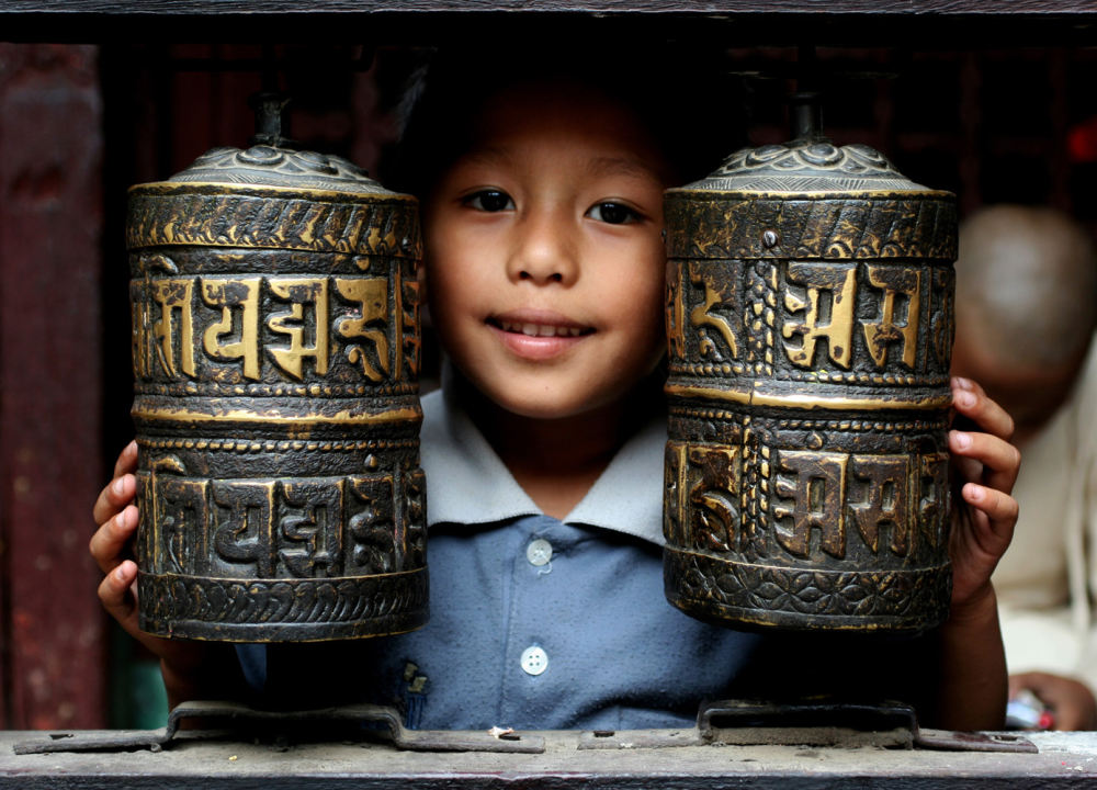
木斯塘,深藏在喜马拉雅山脉的雨云深处;
她曾是尼泊尔境内最后一个自治王国,藏传佛教文化的发祥地,仍保持着15世纪以来的风貌浓缩了西藏文化及宗教传统的时间胶囊;
山谷里方可一览历经风雨沧桑的王国都城,感受蕴藏在古寺村落中的古老魅力;
和BM一起不远千里翻山越岭,探寻即将消失的藏传佛教秘境,喜马拉雅最后的王国-木斯塘Mustang!
Arrival in the capital of Nepal. Depending on the arrival time, we make a city tour to see some contrasts and animations in the streets of Kathmandu. A local guide shows us his hometown: Kathmandu, its old streets and temples. He also gives us a first glimpse into the lives of Nepali.
Accommodation : (or similar)
Meal : Lunch; Supper
Highest Altitude : 1360 meters


- Reference Hotel Pictures


After breakfast, drive to the west of Nepal. It is a beautiful drive in the countryside, and along the banks of the rivers Trishuli and Marsyandi. We also observe lifestyle in the countryside. Afternoon, we reach Pokhara, the city of Lake Phewa that reflects snowy peaks in its waters. Free after noon to do boating on Lake Phewa and to see busy streets.
Accommodation : (or similar)
Meal : Breakfast; Lunch; Supper


- Reference Hotel Pictures


We take a domestic flight between Pokhara and Jomsom (2720 m). When the weather is clear, this short mountain flight offers a magnificent view of mountains Annapurna (8091m), Machhapuchhre (6997m) and Daulagiri. Jomsom is in the valley of Kali Gandaki, the deepest valley in the world. We start with an easy trek along the bank of Kali Gandaki River between Jomsom and Kagbeni (2800 m), the doorway to Upper Mustang, also called the last kingdom of Nepal. In the afternoon, we visit a beautiful Buddhist monastery at Kagbeni dating back to 14th century.
Accommodation : KagbeniAlpine Hut
Meal : Breakfast; Lunch; Supper
Trekking Time : 2-3 hours
Altitude Gains & Losses : +200 meters
Highest Altitude : 2810 meters


Today, we enter Upper Mustang and we go upstream of the Kali Gandaki River. It’s an arid landscape all around. Soon we reach the fortified village of Thangbe with its Buddhist shrines and we also see some green farmlands here. The trail continues through the dry valley, where we can observe hanging cliffs with caves. We pass through the village of Chusang, we continue to follow the river before a last climb to the village of Chele.
Accommodation : CheleAlpine Hut
Meal : Breakfast; Lunch; Supper
Trekking Time : 5-6 hours
Altitude Gains & Losses : +900/-230 meters
Highest Altitude : 3070 meters


We start with a gradual uphill trek to the the Chale-La Pass (3600m) from where we have a beautiful view of the village of Gyakar. Now, the path gently descends to the beautiful village of Samar before we climb up to another Pass: Bhena-La (3830m). From the village of Bhena, we have a magnificent view of Mt. Damodhar. We have yet another climb to the Yamda-La pass (3870m). We pass through the village of Syangmochen and again we cross a mountain pass before we do a long descent to the village of Geling. This village has a castle, a palace and two Buddhist monasteries.
Accommodation : GelingAlpine Hut
Meal : Breakfast; Lunch; Supper
Trekking Time : 5-6 hours
Altitude Gains & Losses : +1270/-785 meters
Highest Altitude : 3570 meters


We continue our trek in the Kali Gandaki valley and climb to the village of Chunkar. This village also has a beautiful Buddhist stupa. Again, we cross two passes: first, we do a steep climb to Nya-La Pass (3990m) and then we cross the Ghami-La Pass (3770m) before reaching the village of Ghami. Ghami is a small green oasis in the middle of an arid landscape. We walk along a wall of stones with holy mantras written on them then we follow another barren valley. On the way, we come across several Buddhist monuments before arriving at the village of Dhakmar.
Accommodation : DhakmarAlpine Hut
Meal : Breakfast; Lunch; Supper
Trekking Time : 5-6 hours
Altitude Gains & Losses : +735/-500 meters
Highest Altitude : 3820 meters


We start the day with an uphill walk to the Moi-la Pass (4145m) then we descend to a Tibetan-style monastery in Nepal: Ghar Gompa, that belongs to the oldest Buddhist school of "Ningma" in Tibet. We can see statues and frescoes. We now begin a long descent through the villages of Lo-Gekar and Marang to reach Tsarang, another wonderful oasis with its fertile land: mustard fields, barley and buckwheat. Visit the palace and the village monastery.
Accommodation : TsarangAlpine Hut
Meal : Breakfast; Lunch; Supper
Trekking Time : 3-4 hours
Altitude Gains & Losses : +370/-575 meters
Highest Altitude : 3560 meters


We follow the Tholung valley up to the Lo-Pass (3945m), decorated with Buddhist prayer flags. The Pass offers a splendid view of the capital of Mustang Lo-Manthang and its surroundings. We have now a short descent to Lo-Manthang, a walled city from the 14th century.
Accommodation : Lo ManthangAlpine Hut
Meal : Breakfast; Lunch; Supper
Trekking Time : 3-4 hours
Altitude Gains & Losses : +350/-125 meters


Day visit and rest at and around Lo manthang, a hidden city from the 15th century. We walk through the streets of the village and discover the two historical monasteries, Jamba Lhakhang and Tukche to see some splendid paintings.
We can also visit another valley above Lo Manthang by hiring horses. Chosar (3987m), a village towards the Tibetan border, has impressive cave dwellings that we can visit for a fee. The views of ruined forts, Buddhist chortens and barren hills make this day a wonderful one.
Meal : Breakfast; Lunch; Supper
Trekking Time : 4-5 hours


We walk to the village of Dhi, climbing some ridges and a steep descent leads to the river and the village, which also has a beautiful fort in ruins. We cross the Kali Gandaki River and climb through a gorge with huge cliffs before arriving at Yara.
Accommodation : YaraAlpine Hut
Meal : Breakfast; Lunch; Supper
Trekking Time : 4-5 hours
Altitude Gains & Losses : +350/-700 meters
Highest Altitude : 3640 meters


Today, we do a round trip. After breakfast, we leave for the Luri Gompa Monastery, famous for its frescoes and beautiful stupa. Back at Yara, we have a free afternoon to enjoy each of her or his way the beauty of the area.
Accommodation : YaraAlpine Hut
Meal : Breakfast; Lunch; Supper
Trekking Time : 3-4 hours
Highest Altitude : 3850 meters


We walk quite long up to a Pass at 3700m and then walk along a steep descent to the river Dhe Khola. Here, the scenery is always impressive and desert-like, and we have the impression that this is the end of the world! Shortly, we cross a second Pass at 3900m and then an easy descent at first but quite steep in the end, leads us to the village of Tangye (3320m).
Accommodation : TangyeAlpine Hut
Meal : Breakfast; Lunch; Supper
Trekking Time : 5-6 hours
Altitude Gains & Losses : +1360/-260 meters
Highest Altitude : 3900 meters


Today, we start the trek a little earlier because it is the longest day of the trek. But it is probably the most beautiful day, with diverse landscapes. From a 4100m Pass on the way, we have a splendid panorama on Mustang, but we can also see giant peaks: Annapurna (8091m) and Dhaulagiri (8167m). After a long, gradual descent, we arrive at the village of Chusang.
Accommodation : ChusangAlpine Hut
Meal : Breakfast; Lunch; Supper
Trekking Time : more than 8 hours
Altitude Gains & Losses : +950/-1100 meters
Highest Altitude : 2980 meters


We have a long climb through the gorge of a river to Gyu La (4050m) Pass, and then we walk downward via the village of Chyongur to Muktinath. Muktinath is a holy place, where Hindu and Buddhist beliefs are mixed. A Pagoda temple of Vishnu with 108 water taps around it and a Buddhist monastery with a sacred natural gas flame burning eternally are two nice sights to see. From here, we have a stunning view of Dhaulagiri (8167m), Nilgiri (7061M) and Tilicho Peak (7134m). Dhaulagiri means "white mountain".
Accommodation : MuktinathAlpine Hut
Meal : Breakfast; Lunch; Supper
Trekking Time : 5-6 hours
Altitude Gains & Losses : +1100/-400 meters
Highest Altitude : 3802 meters


We have a long walk downward and we reach Kali Gandaki River, near the starting point of our trek few days ago. We pass through the villages of Jharkot (3560m) and Ekle Bhatti (2740m) and we reach Jomsom.
Accommodation : JomsomAlpine Hut
Meal : Breakfast; Lunch; Supper
Trekking Time : 4-5 hours
Altitude Gains & Losses : -1050 meters
Highest Altitude : 3560 meters


conditions can alter the flights; alternative: drive to Pokhara: 8 hours on a rough road).
Meal : Breakfast; Lunch; Supper

Free time in Kathmandu. (Security Day in case of Flight Jomsom/Pokhara cancellation)
Accommodation : (or similar)
Meal : Breakfast; Lunch; Supper


- Reference Hotel Pictures
Transfer to airport for departure to China.
Meal : Breakfast; Lunch; Supper

Route Type 徒步
Route CodeNEPMST1
Follow our subscription account to stay informed about the latest Pama information and the most unique outdoor travel routes around the world.

For online consultation, route consultation, event customization, and business cooperation, please add Xiaoma WeChat.