在壮丽的菲亚拉巴克自然保护区和瓦特纳冰川国家公园进行为期七天的徒步之旅。穿行在冰与火的土地上,沙漠与湖泊,最原始的生态,人迹罕至的道路,平静生活的动物,喜怒不定的活火山,一场无与伦比的风光盛宴。欣赏冰岛最典型的冰雪山川、熔岩、火山口和热湖,很难想象“冰与火”在这片大地竟展现出极其和谐的一面。同时,我们配备全程行李运输服务,只需携带一个装有午餐和徒步旅行所需额外衣物的日用背包,轻装开展冰岛最自然的景观。

品牌联合创始人; 人文户外产品总监 ; 资深户外玩家和从业者;
05年始从事户外活动, 以行走的方式游历过70余个国家, 攀登过四大洲数座六千米以上山峰, 擅长于户外成人和亲子产品设计, 长期追寻与实践一种人文探索与户外运动相结合的旅行方式。
Arrival at Keflavik airport. From there we will take the bus line (Flybus) that, crossing the
northern area of the Reykjanes peninsula, will take us to the capital (45 km). Accommodation
in hotel.
Accommodation : (or similar)
Meal : (On Own)


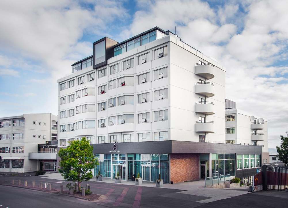
- Reference Hotel Pictures
四星海岛酒店临近雷克雅未克的主要街道,在酒店天台可以放眼山脉全景。

The tour starts in Reykjavík. We pick up at Reykjavík bus stops and most hotels in Reykjavík. The pickup starts at 8.30.
From Reykjavík we set the course to the Golden Circle one of the most popular routes in Iceland and well known for beautify its landscape. We will visit the UNESCO world heritage site Thingvellir National Park that is geologically significant where the tectonic plates remnant is visible as the park is rifted by the North American and Eurasian tectonic plates. Thingvellir national park is also historically important as it is where the Icelandic parliament was established in 930 AD.
From Thingvellir we travel to the Geysir geothermal area where the famous Strokkur geyser erupts every 5 to 10 minutes, shooting hot water up to 20 – 30 meters in the air.
We will visit Gullfoss waterfall one of Iceland most fantastic waterfall and after lunch we start to drive to the highlands with Landmannalaugar as our end destination for this day.
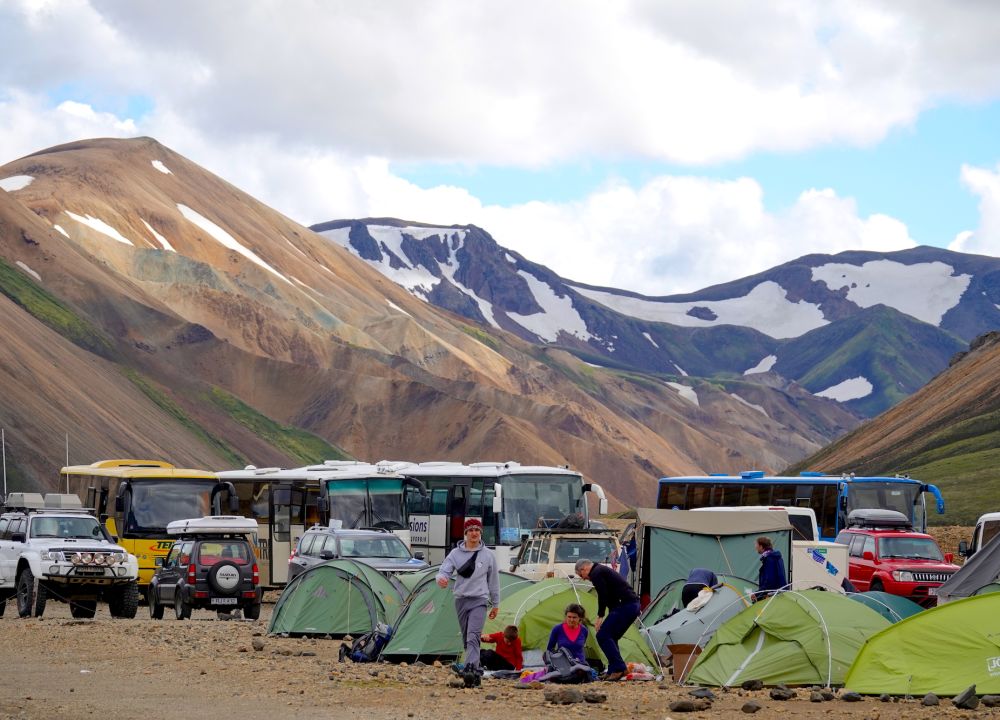
Landmannalaugar, a place that is well known for its colorful mountains, hot springs, and beautiful lava field. Landmannalaugar is in the Fjallabak Nature Reserve. It is a protected wilderness area that is known for its rugged and dramatic landscapes, geothermal features, colorful rhyolite mountains, and pristine wilderness.
In Landmannalaugar the group will set up camp for the night and cook dinner in our group canteen tent. The travelers will sleep in tents at Landmannalaugar.
Relaxing in the natural geothermal hot spring at Landmannalaugar is an option.
Accommodation : Landmannalaugar tent camp (or similar)
Meal : Breakfast; Lunch (Picnic); Supper (Camp Meal)


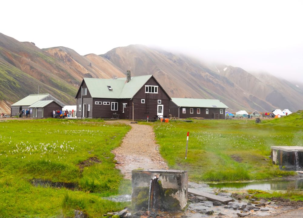
- Reference Hotel Pictures
兰德曼纳劳卡露营,躺在山谷之中,看满天繁星,享受大自然的恩惠。
The day starts in our group canteen tent where we have breakfast. During breakfast the trekkers have access to a few kinds of bread, toppings, soups, biscuits, fruits, and energetic food that can be brought on the days hike as lunch and snack. In beginning of each trekking day, the trekkers must prepare a lunch pack for the day. The trekkers carry what they need for the day in their day pack such as lunch and snacks and some extra clothes. Everything else will be transferred by 4x4 vehicle to the next camp site.
The trek starts with a trek through the Laugahraun lava to the mountain Brennisteinsalda. We will observe bubbling rivers, geothermal hot springs, beautiful lava, and colorful mountains on way as the group hike to mountain Hrafntinnusker, 1100 meters above sea level. The view from there is fantastic as we will have stunning panoramic views of the surrounding volcanic landscape and nearby glaciers. The mountain Hrafntinnusker is is also known for its abundance of obsidian, a black volcanic glass formed from rapidly cooled lava.
From Hrafntinnusker we begin descending to Lake Álftavatn where we camp over the night. Lake Álftavatn is midway Laugavegur trail, and we have now covered half of that trail and the most interesting and colorful area. Next day we will turn off the Laugavegur trail to go of the beaten path to explore less travelled area.
Accommodation : Alftavatn tent camp (or similar)
Meal : Breakfast; Lunch (Picnic); Supper (Camp Meal)
Trekking Distance : 24 kilometers
Trekking Time : 7-8 hours
Altitude Gains & Losses : +900 meters


- Reference Hotel Pictures
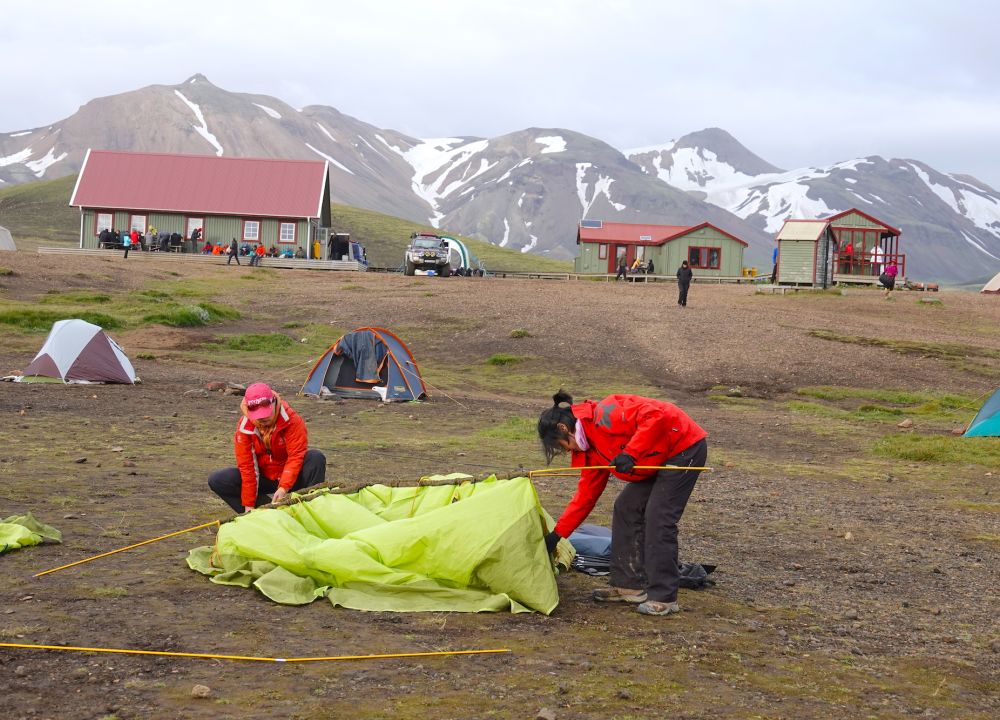
冰岛旅游协会在中路阿尔夫塔湖上的山间小屋建于1979年,可容纳58人。

After breakfast and preparation of lunch and snack for the day hike, we begin the trek viewing Lake Álftavatn. The lake lies in the heart of the Icelandic Highlands, surrounded by breathtaking volcanic landscapes. Lake Álftavatn is known for its stunning natural beauty, with crystal-clear waters reflecting the surrounding mountains and lava fields.
From Álftavötn we continue our exploration as we go off the beaten path. The path is unmarked and not visible and far from all roads. We will enjoy different landscape rest of this day as we hike onto the Mælifellssandur with the black sand around us green hills in the background and good view on the magnificent glacier Mýrdalsjökull where the volcano Katla is resting.
We trek through the black volcanic sand of Mælifellssandur to the ridge Slysaalda a mysterious place of old storis of hidden outlaws and tragic accident in the year 1868. We finally trek over a small mountain ridge called Veðurháls before we reach the Strútur hut and campsite where we will stay overnight.
We will cook and have dinner inside the hut. Explorers can choose between sleeping in their tents or using the accommodation in the hut.
Accommodation : Strútur Hut (or similar)
Meal : Breakfast; Lunch (Picnic); Supper (Camp Meal)
Trekking Distance : 15 kilometers
Trekking Time : 6-7 hours
Altitude Gains & Losses : +600 meters
Highest Altitude : 1920 meters


- Reference Hotel Pictures
露营地位于Mælifellssandur的Mount Strút的户外休闲小屋旁。鸵鸟露营地是东部阿尔夫塔湖和西部的 Hvanngil 或 Emstra 之间的理想休息场所。客人可以在山林小屋附近选择许多有趣的远足径。


From Strútur hut we set the course Strútslaug, that lies south of the glacier Torfajökull. Strútslaug is an active geothermal area and there the explorers can relax in fully natural geothermal hot spring. There are no dressing rooms there and we don’t expect to meet other trekkers in this remote area that is not accessible by roads or tracks either.
From Strútur hut to Strútslaug there is a 1.5-hour hike. We take a break at Strútslaug and then we continue our journey as we hike alongside the vast Svartahnúksfjöll “black mountains” we will hike into the Eldgjá Canyon and to the lake Álftavötn.
Lake Álftavötn is a wide valley loaded with lakes and rivers. Álftavötn means “Swan lakes” It is common to see birds there like swans and other birds depending on the time of the year. We stay in the Álftavötn hut during the night. We will cook and have dinner inside the hut.
Accommodation : ÁLFTAVÖTN HUT (or similar)
Meal : Breakfast; Lunch (Picnic); Supper (Camp Meal)
Trekking Distance : 21.8 kilometers
Trekking Time : 7-8 hours
Altitude Gains & Losses : +300 meters


- Reference Hotel Pictures
Álftavötn小屋是农民从高地上放牧羊群时使用的老房子。Útivist的成员几年前重建了它,现在它是一个非常舒适和舒适的小屋。


We leave the hut in Álftavatnskrókur in the morning. We are surely off the beaten path now as there are no known trails or treks. We are trekking alongside and inside the Eldgjá Canyon fissure as we enter the Vatnajökull National Park.
The Eldgjá Canyon fissure is a 70 km long canyon reaching from the glacier Mýrdalsjökull, where the Katla volcano lures, to the peak Gjátindur (943 m). We set the course to the Peak Gjátindur where the view over the canyon and the highland of Iceland is truly magnificent.
Eldgjá canyon fissure was created by eruptions that took place in the year 934. In our trek we will observe the fissure and take a good look at the waterfall Ófærufoss.
The total lava flow from the Eldgjá eruption is estimated to be around 19 cubic kilometers. That makes the Eldgjá eruption the most volumetric lava flow from one eruption in historical time. The origins of the Eldgjá eruption are from the Katla volcano system.
From peak Gjátindur our way is downhill towards the river Skaftá. The end destination this day is Skælingar, where the most adventurous hikers will be able to bathe in a cold mere.
In Skælingar there is an old Shepards cabin. It was initially built by the farmers in this part of Iceland. It is one of many such cabins in Iceland that were used in the autumn in the sheep round-up, when farmers collected sheep from the Highland.
Skælingar is a wonderful world of unusual lava formations. A place where everything is calm and quiet but a place that looks strange and exotic. In Skælingar there are many amazing lava formations from Laki crater eruption that took place in the year 1783 (Skaftáreldar) that are beautiful scenery.
Accommodation : Skælingar Hut (or similar)
Meal : Breakfast; Lunch (Picnic); Supper (Camp Meal)
Trekking Distance : 20 kilometers
Trekking Time : 6-7 hours
Altitude Gains & Losses : +500 meters


- Reference Hotel Pictures
Skælingar的小屋是一间古老的小屋,是农民从高地上放牧羊群时使用的。Útivist的成员几年前重建了它。小屋的特点是古老的冰岛建筑传统,墙壁由石头制成,因此客人在自然环境中体验冰岛的文化传承。小屋周围都是非常特殊的熔岩构造。


The days trek is alongside the river Skaftá and by the mountain Uxatindar to the valley Hvanngil in in a fabulously colorful landscape. The views are a momentous part of the trip and are unforgettable. Our destination this day is the shepherds hut at the foot hill of the mountain Sveinstindur where we will stay overnight.
Accommodation : Sveinstindur hut (or similar)
Meal : Breakfast; Lunch (Picnic); Supper (Camp Meal)
Trekking Distance : 18 kilometers
Trekking Time : 7-8 hours
Altitude Gains & Losses : +300 meters


- Reference Hotel Pictures
Sveinstind 小屋曾经是农民从高地收集羊群的地方,但 Útivist 的成员几年前重建了它。古老的石墙被使用,冰岛文化传统得以保留。


After breakfast the trek begins by hiking to the top of peak Sveinstindur (1.090 m)
The view from the top is spectacular. The view stretches over the breath-taking valleys, mountains, and glaciers. The hike from the hut to the peak will take 4 hours. The starting destination at the bottom of Sveinstindur is around 500 meters above sea level and the top is 1090 meters. The elevation is therefore 5-600 meters.
Lake Langisjór in the national park, one of Europe’s most beautiful and pristine highland lakes, is tucked in between the beautiful Tungnárfjöll and Fögrufjöll Mountains at the western edge of Vatnajökull Glacier. Measuring 20 km long and 2 km wide in some places, the lake is 27sq km and 75m at its deepest and lies some 640m above sea level. T
The view around the lake is magnificent and at the southern end of the lake Langisjór stands peak Sveinstindur (1090 m) which is considered by many to be one of the best views of the panorama of the surrounding area. The view stretches over all the lake Langisjór additionally, an unforgettable sight to see. To the right of the lake is the mountain range Fögrufjöll with numerous lagoons between heights and peaks. East of the mountain range Fögrufjöll runs the glacier river Skaftá, which has historically crashed with catastrophic floods. The floods originate in Skaftárkatlar, which is a geothermal area underneath the glacier Vatnajökull. From the east of the Skaftá river, one can see the crater Lakagígar, where the lava from the Laki fissure flooded in the lowlands in 1783 – the third largest lava flow on earth since the last Ice Age.
From peak Sveinstindur we will descend toward lake Langisjór and hike to our pickup location where the group will be picked up by a 4x4 truck that transfer the group of the highlands to the lowland where we will drive the South Coast Road back to Reykjavík City. We will drive through the town of Vík where we will stop for refreshment and from there, we will visit the Black Beach (Reynisfjara). Estimated arrival in Reykjavík City is at 18.00
Accommodation : (or similar)
Meal : Breakfast; Lunch (Picnic); Supper (Camp Meal)
Trekking Distance : 4 kilometers
Trekking Time : 3-4 hours
Altitude Gains & Losses : +600 meters


- Reference Hotel Pictures
四星海岛酒店临近雷克雅未克的主要街道,在酒店天台可以放眼山脉全景。
tbd
Accommodation : Own arrangement
Meal : Breakfast
Route Type 徒步
Route CodeB58-ISTRK2
Follow our subscription account to stay informed about the latest Pama information and the most unique outdoor travel routes around the world.

For online consultation, route consultation, event customization, and business cooperation, please add Xiaoma WeChat.